GSLV Mk II | NISAR (NASA-ISRO Synthetic Aperture Radar)
Launch Successful
L - -- : -- : -- : --
Instantaneous launch window.
Launch Window
July 30, 2025, 12:10 p.m. - July 30, 2025, 12:10 p.m.
Instantaneous launch window.
July 30, 2025, 12:10 p.m. - July 30, 2025, 12:10 p.m.

NASA-ISRO Synthetic Aperture Radar (NISAR), the first joint satellite of ISRO and NASA will be launched by ISRO’s GSLV-F16 on July 30, 2025 at 1740 hrs IST from Satish Dhawan Space Centre (SDSC SHAR), Sriharikota. GSLV-F16 will inject the NISAR satellite into a 743 km Sun-synchronous orbit with an i...
The NASA-ISRO Synthetic Aperture Radar, or NISAR satellite, will use advanced radar imaging to map the elevation of Earth's land and ice masses 4 to 6 times a month at resolutions of 5 to 10 meters. It is designed to observe and measure some of the planet's most complex natural processes, including ecosystem disturbances, ice-sheet collapse, and natural hazards such as earthquakes, tsunamis, volcanoes and landslides. Under the terms of the agreement, NASA will provide the mission's L band synthetic aperture radar (SAR), a high-rate telecommunication subsystem for scientific data, GPS receivers, a solid-state recorder, and a payload data subsystem. ISRO will provide the satellite bus, an S band synthetic aperture radar, the launch vehicle, and associated launch services.

Satellite in operation.
Spacecraft separation.
Liftoff.

Official Webcast by NASA has started
GO for launch.
Geosynchronous Satellite Launch Vehicle Mark II (GSLV Mk II) is the largest launch vehicle developed by India, which is currently in operation. This fourth generation launch vehicle is a three stage vehicle with four liquid strap-ons. The indigenously developed cryogenic Upper Stage (CUS), which is flight proven, forms the third stage of GSLV Mk II. From January 2014, the vehicle has achieved four consecutive successes.
The Indian Space Research Organisation (ISRO) is the space agency of the Government of India headquartered in the city of Bangalore. Its vision is to "harness space technology for national development while pursuing space science research and planetary exploration."
INFO WIKI
One of the most powerful radar systems ever launched into space has mapped the ground moving beneath one of fastest subsiding capitals in the world: Mexico City. The findings show how quickly and reliably the NISAR (NASA-ISRO Synthetic Ape…
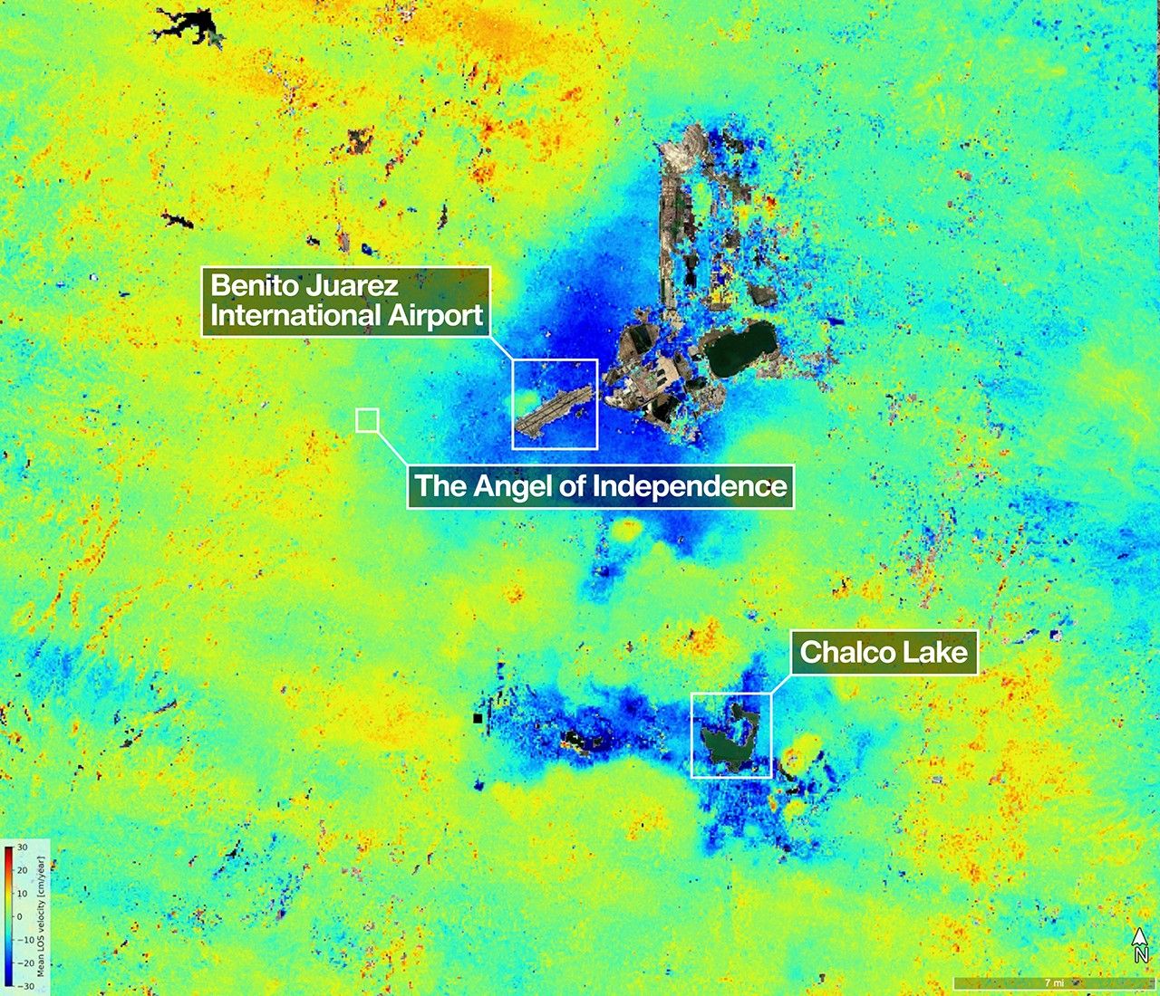
Description A scientist produced this map of land subsidence (sinking) in Mexico City using data from the NISAR (NASA-ISRO Synthetic Aperture Radar) mission captured between Oct. 25, 2025, and Jan. 17, 2026. The region has been a well-know…

Seattle and Portland, Oregon, are among the cloudiest cities in the United States. But that infamous cloud cover is no match for the U.S.-Indian Earth satellite NISAR (NASA-ISRO Synthetic Aperture Radar), which is designed to peer straight…

Los Angeles CA (SPX) Feb 02, 2026 A new radar image from the joint NASA-ISRO NISAR satellite shows how the mission can see through cloud cover to reveal surface features across the Mississippi River Delta region in southeastern Louisi…

Description The NISAR (NASA-ISRO Synthetic Aperture Radar) Earth-observing satellite’s L-band synthetic aperture radar (SAR) instrument captured this image of the Mississippi River Delta region in southeastern Louisiana on Nov. 29, 2025. T…
Fourteenth batch of satellites for a reconnaissance satellite constellation built by SpaceX and Northrop Grumman for the National Reconnaissance Offi…
Amazon Leo, formerly known as Project Kuiper, is a mega constellation of satellites in Low Earth Orbit that will offer broadband internet access, thi…
AST SpaceMobile’s Block 2 BlueBird satellites are designed to deliver up to 10 times the bandwidth capacity of the BlueBird Block 1 satellites, requi…
Note: Unofficial reports indicate there may be 1 or more additional satellites that failed to separate from the upper stage, however this is not offi…
A batch of 9 Low Earth Orbit communication satellites for the Chinese state owned SatNet constellation operated by the China Satellite Network Group.…
Classified experimental Chinese satellite of unknown purposes (officially described for "spatial environment detection" purposes).
A batch of 24 satellites for the Starlink mega-constellation - SpaceX's project for space-based Internet communication system.
8 Earth observation satellites for the Jilin-1 commercial Earth observation satellites constellation: * High Resolution-04D 01-02 * High Resoluti…
A batch of 29 satellites for the Starlink mega-constellation - SpaceX's project for space-based Internet communication system.
Test flight of the H3-30 variant of the H3 launch vehicle with 3 LE-9 engines in the first stage and no SRBs. The flight will carry a dummy main payl…